Big Island of Hawaii Must See & Do
Hawaii Volcanoes National Park
Chain of Craters Road may be one of the unique experiences you have on the Big Island. Stretching 18 miles and going from 4,000 ft. elevation to sea level, this scenic drive along the East Rift Zone of the volcano in HVNP is pockmarked with craters of varying shapes and sizes, lava flows, petroglyphs, and, possibly, active lava.
Along this road, you will also find many interesting hikes, breathtaking vistas, and when she's actively erupting, the opportunity to see Madame Pele (the Hawaiian goddess of fire and volcanoes) do what she does best.
— article continued below —
2024 Big Island Visitor Guides
Visiting the Big Island of Hawaii soon? Be sure to grab your copy of one of our updated Big Island Visitor Guides.
~ Trusted by Millions of Hawaii Visitors Annually ~

The Chain of Craters Road
To reach Chain of Craters Road from the entrance to the park take a left onto Crater Rim Drive just after you pass the gate. Follow Crater Rim Drive for three miles until you reach Devastation Trail. Chain of Craters Road will be on the left directly across from the Devastation Trail parking lot. It is important that you reset your car odometer as all the mile markers in our guide are based on the true mileage and not the park mile markers which can sometimes be inaccurate.
If your ultimate goal is night time lava watching (applicable only when active flows are present), you may want to start out on Chain of Craters several hours before sunset in order to reach the end of the road with enough time to get out to the lava before dark. Add extra time if you plan on doing any of the hikes along the road.
Mile Marker .02 1974 Lava Tree and Keanakakoi Crater Hike Mile Marker 0.4 Lua Manu Crater
The first of several marked craters along this road, Lua Manu will be on your right. Lua Manu is a pit crater that is formed when magma below the earth's surface drains, causing the earth to collapse. The 1974 flow sent lava pouring into Lua Manu's basin which is 109 yards in diameter. Further down the road at 0.9 you will see a small pullout on the left which leads to another pit crater, Puhimau Crater.
Mile Marker 1.3 Thermal Hotspot Mile Marker 1.5 Ko'oko'olau Crater
Ko'oko'olau is different from the other pit craters we have seen on this road because it has not seen lava in over 200 years. Now, ohia and koa trees and other vegetation have filled the area.

Mile Marker 2 Hilina Pali Road
The 8.2 mile trip down narrow Hilina Pali Road may not offer much in the way of gorgeous scenery. However, the breathtaking views at the end are worth the effort if you have the time. The paved road leads you past the vegetation of Chain of Craters Road into the arid, scrubby environment of the Ka'u Desert. Camp Kulanaokuaiki is about four miles down Hilina Pali Road followed by the head of the 6.3 mile Mauna Iki Trail and later the old Kipuka Nene Campground. Kipuka Nene has been closed since the endangered nene, the state bird of Hawaii similar to a Canadian goose, began nesting there but don't expect to see a lot of nene hanging around. Although if you do, please do not disturb them or offer them food. Occasionally Hilina Pali is closed due to fire or nene nesting. The road continues to twist and turn over the bumpy and rutted pavement until you finally reach the Hilina Pali Lookout - this could take as long as half an hour. The lookout boasts a covered picnic pavilion and a pit toilet. You can walk a hundred yards down the trail to an extraordinary view of the pali (cliff in Hawaiian). With the strong winds whipping around you and the expanse of land in front, it seems like the end of the world - a wild and beautiful place. It was also the site of a disaster in 1975 when a 7.2 magnitude earthquake shook portions of the pali free. The collapse caused a tsunami that killed two campers at Halape camp on the coast. There is a small plaque in their memory. The return trip is easy, simply go back to where you came from being mindful of oncoming traffic trying to share the portions of a one-lane road.
Mile Marker 2.2 Devil's Throat
Just after you turn back onto Chain of Craters Road, look for a small pullout on the right. Park and walk across the road to a dirt path. The path leads about 50 feet to the edge of a sheer cliff which drops off into the abyss. This massive 150 ft. wide by 165 ft. deep crater is called Devil's Throat, and one can imagine why. There are no guard rails to block you so please step carefully around the crumbling edges of the pit. Further down the road at mile marker 2.5 is Hi'iaka Crater with Pauahi Crater following at 3.1. Pauahi is massive at 1,800 feet long and a boardwalk is provided for a better view.
Mile Marker 3.6 Mauna Ulu and Napau Crater Trail
After passing the Pauahi crater, look for a spur road to the left. Follow it about half a mile to a parking lot with a restroom. At the end of the road, there is a path that leads to the Napau Crater Trailhead. The entire trail is over seven miles long and requires a permit. However, the first leg, a little over a mile will take you to Pu'u Huluhulu, a tree-draped cinder cone. This area is the site of Kilauea's second-longest flank eruption in known history. The trail zigzags through a field of jagged a'a and smooth pahoehoe lava from 1974 flows. The path is fairly well worn but make sure to follow the small reflective trail makers set out on the lava. Take a moment to observe this varied landscape. There will be small groupings of trees and plant life that seems to spring out of nowhere amidst a field of pitch-black lava. These areas, called kipukas, are parcels of land that by luck were spared from the lava flows. Several lava trees and massive lava bombs also dot the trail. After about a mile of trekking across the lava, you will reach Pu'u Huluhulu, which is literally translated "hairy hill" because of the wealth of vegetation that has overgrown the crater. The trail snakes up the side of the crater in a series of switchbacks eventually leading to an observation area. This hike is best done on a clear day because of what you might see off in the distance to the east. If conditions are right and the volcano is active, you should be able to glimpse Pu'u O'o, the center of Kilauea's current eruption, belching white smoke up into the sky. If you decide to hike this at night, you may be treated to the red glow of flowing lava. From the top of Pu'u Huluhulu, you can also see Mauna Ulu to your right which flooded this area with lava from 1969-1974. From the bottom of the crater, the Napau Trail continues on to Napau Crater and Camp. The journey to Napau is seven miles one way over the wild and fascinating landscape. The trail skirts around the mouth of Makaopuhi Crater and eventually ends at Napau Camp which has neither water nor shelter. Rangers recommend a stock of at least three quarts of water per day for the hike. A camping permit can be obtained from the Kilauea Visitor Center.
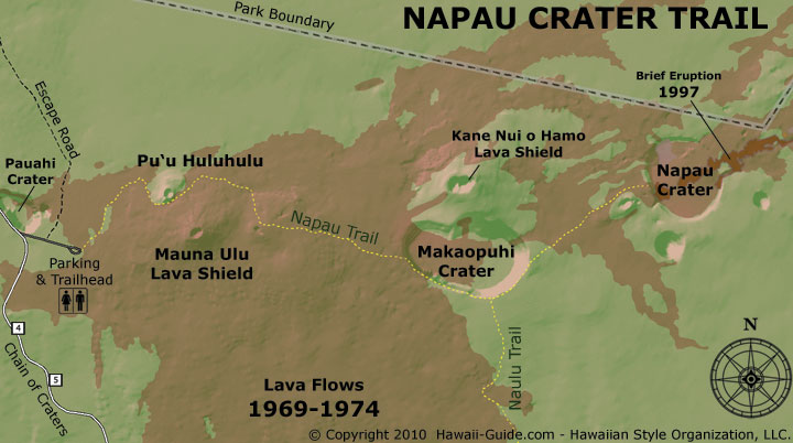
Napau Crater Trail
Mile Marker 6.2 Mau Loa O Mauna Ulu
From the pullout, you can see a sprawling black sea of pahoehoe lava, which originated from the 1969-1974 eruption of Mauna Ulu. The Keauhou Trail begins here and continues eight miles to the Keauhou Camp on the coast.
Mile Marker 9.6 Kealakomo
As you approach the ten-mile marker, a wooden hut perched on the side of the cliff will come into view - an odd site for sure. The handicapped-accessible Kealakomo is built on the Holei Pali and peers down over a 2,000 ft drop to the ocean. The pavilion faces the direction of the Kealakomo village, which was destroyed in a 1971 lava flow. The covered picnic tables may look inviting, but this spot can be quite windy, perhaps a better place to lose your lunch than eat it. The Naulu Trail begins across the street. It eventually connects with the Napau Crater Trail to the north. It also intersects the unmaintained 10-hour Kalapana trail.
Mile Marker 10.2-15.9 various lookouts
If you are itching for another opportunity to view the coast, pull over at the Halona Kahakai pullout at mile marker 10.2. Depending on where the lava is flowing during your visit, you may be able to see the steam plume where the lava is entering the ocean. Near mile marker 11.5, the road takes a dramatic hairpin turn, which you should approach with caution. In another mile, the elevation will have dropped to 1,000 ft as you rapidly approach the coast. Building a road on an active volcano is a practice in patience, as evidenced by the Alanui Kahiko pullout at mile marker 13.7. The pullout marks the location of the old Chain of Craters Road, which was coated in lava by the Alae Lava Shield flow of 1972. You can still see sections of it peeking out from underneath the lava. To fully grasp the enormous power of the volcano that you are driving on, pull over at mile marker 14.4 at Holei Pali lookout. It is easy to see how the lava came pouring in waves over the Holei Pali, forming gigantic swaths down the hill. The lava oozed its way to the ocean to continue building the Big Island.

Mile Marker 15.9 Pu'u Loa Petroglyph Field
The Big Island has the highest concentration of ancient Hawaiian stone carvings in the state. Some have estimated that the Pu'u Loa Petroglyph Field has between 15,000 and 20,000 drawings. Once you reach mile marker 15.9, you'll see two pullouts on either side of the road and a small park sign marking the start of the .7 mile petroglyph trail. The walk to Pu'u Loa takes you over an ancient field of rolling lava with small scrubby plants pushing their way through the cracks. The path is well-worn and marked by cairns (little piles of rocks). The pali rise to your left and if you look over the ridge, you could see Pu'u O'o chugging out its volcanic fumes. The park has built a boardwalk to protect the fragile carvings while still allowing visitors to enjoy them. You may see drawings of men with broad shoulders or long torsos. Above all others, the set of concentric circles with a small dimple in the center is ubiquitous. Fathers would place pieces of their newborns' umbilical cords in the holes as a way to ensure a long life. The ancient Hawaiians had no written way of communication, and it's believed these drawings could have been used for that purpose. Please be mindful of the extremely valuable nature of these drawings. Do not touch or make rubbings of the petroglyphs as it compromises the carving. If you are in this area towards dusk, you may notice, depending on the wind, that some VOG (volcanic gases) may settle here. These gases have a strong and slightly sulfuric smell, which also leaves a metallic aftertaste. In small doses, VOG will not harm a healthy person, but it is not recommended that pregnant women, those with heart or lung conditions or small children, should be exposed.

Mile Marker 18.3 Holei Sea Arch
In a park where the main attraction is an ever-changing force of nature, there is no telling how the landscape could change. Since 1983 Kilauea has been eating portions of the Chain of Craters Road and covering the villages on it with its lava flows. In early 2003, lava buried portions of the Chain of Craters Road, which prompted park rangers to limit vehicle travel at mile marker 19.3. Currently, the park has set up a turn around point with a small ranger station, pit toilets, and a canteen. Parking is available on either side of the road. Once you pass the barricade, on your right is a short trail to the ocean and a view of Holei Sea Arch. Sea arches are formed when lava is continuously pounded by the surf until it is undercut in the shape of an arch.
The end of the road
There are no active flows at the end of Chain of Craters Road at this time.
Currently, the park allows visitors to walk the mile down Chain of Craters Road to where the older lava begins. If you plan on hiking beyond where the lava meets the road, please take a few precautions. Bring plenty of water, approximately three quarts for the entire hike. Carry rain gear, sunblock, and flashlights. The temperature drops with the sun, so carry a lightweight jacket or sweatshirt just in case.
The lava fields are a sight to behold and, for those capable of the hike, a must. Hiking across lava may include unsure footing, jagged rock, and high winds, but the payoff is amazing. The flows stretch in front of you like a massive black ocean glittering in the sun. The lava has created waves and valleys of varying degrees. You can see where the pahoehoe lava has created interesting swirls and ropey patters. The landscape is punctuated by raised hills where gases escaped. To get an idea of how deep this ocean is, you will pass several road signs that were nearly buried by recent flows.
Remember, though, never venture out onto the lava bench nearest to the ocean. This land is very unstable and prone to collapse without warning. Some foolish people have not heeded this warning and paid for it with their lives.
If you are fortunate enough to be here on a clear night, look up. With the only lights being what you are holding in your hand, stargazing is phenomenal.